Display and analyze GIS data on the web with Leaflet

Description:
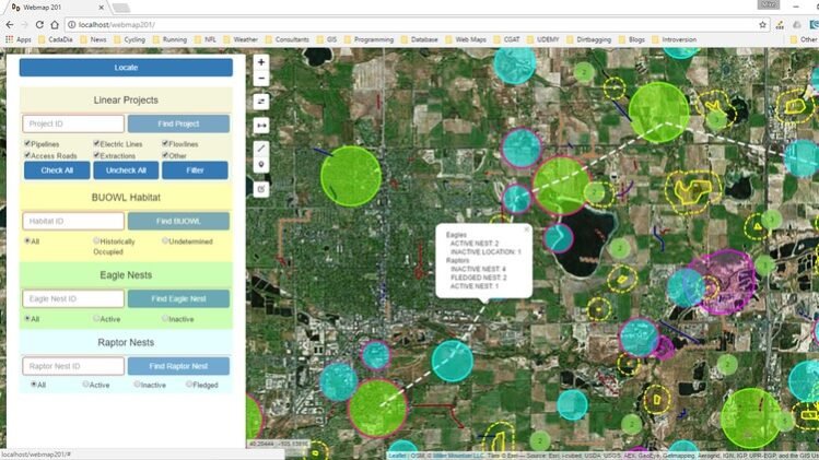
Unlock the power of Geographic Information Systems (GIS) and learn how to visualize and analyze spatial data on the web using Leaflet, one of the most popular open-source JavaScript libraries for interactive maps. In this comprehensive course, you’ll dive into the fundamentals of GIS data, understand the principles of web mapping, and harness the capabilities of Leaflet to create dynamic and customizable maps that can be easily shared and integrated into web applications.
Through hands-on exercises and real-world examples, you’ll learn how to display various types of GIS data, including points, lines, and polygons, and explore advanced techniques such as layer control, custom styling, and interactive pop-ups. Additionally, you’ll delve into spatial analysis and learn how to perform proximity searches, spatial queries, and geospatial operations directly within your web maps.
Requirements:
- Basic knowledge of HTML, CSS, and JavaScript.
- Familiarity with GIS concepts is helpful but not required.
Who This Course Is For:
- Web developers interested in adding interactive mapping functionality to their websites.
- GIS professionals seeking to expand their skills into web mapping.
- Students and enthusiasts eager to explore the intersection of geography and web technology.
Enroll now and take your mapping skills to new heights!
The Leaflet Map Object
-
1
 Introduction
 -
2
Optional - About Me
-
3
Client-Server Architecture
Learn about the basics of client server architecture and how it differs from programming on a single user system.
-
4
Required software for this course
How to download and install the software required for this course.
-
5
Anatomy of a URL
Understand what a URL is and how to work with the local host web server
-
6
Your first web map - Setup
Set up the directory structure necessary for your first web map.
-
7
Your first web map - Code
Writing the HTML, CSS, and JavaScript necessary to create a basic web map
-
8
Leaflet documentation - Part 1
Learn how the Leaflet on-line documentation is organized
-
9
Leaflet documentation - Part 2
Learn how to navigate the Leaflet on-line documentation
-
10
Leaflet Plug-ins
Learn how to find, understand, and load Leaflet plug-ins into your web mapping application
-
11
Optional - Editors
Learn about the editors that are available for different operating systems and their benefits.
-
12
 Section 1 Quiz
Test yourself on the concepts learned in this section
Raster layers in Leaflet
-
13
The Leaflet Map Object - Part 1
Learn the basics of the Leaflet map object
-
14
The Leaflet Map Object - Part 2
Programming the Leaflet map object
-
15
The Leaflet location method
Learn how to use Leaflets location method to locate your device on the map
-
16
Connecting the map object to the DOM
Access the Leaflet map objects events and methods in response to DOM events and modify the DOM in response to map events
-
17
Leaflet popups
Learn about using popups and tooltips in Leaflet
-
18
Native Leaflet controls
Learn how to use and modify the native Leaflet map controls
-
19
Plugin Leaflet controls - Part 1
Replace the native zoom control with a sliding zoom control and add panning buttons
-
20
Plugin Leaflet controls - Part 2
Replace the native Leaflet zoom control with a sliding zoom control and add panning buttons
-
21
Plugin Leaflet controls - Part 3
Add a mouse coordinate and measure control
-
22
Plugin Leaflet controls - Part 4
Learn to install and use the Leaflet easy button and sidebar controls
-
23
Plugin Leaflet controls - Part 5
Learn about some other Leaflet plugin map controls including geocoding and routing.
Vector layers in Leaflet
Styling vector data
-
28
Introduction to vector layers
Learn the basics of Leaflet vector overlay layers
-
29
The marker object
Learn the basics of using Leaflet marker objects for displaying pont data
-
30
The path and polyline objects
Learn about the path abstract object and the Leaflet polyline object
-
31
The polygon object
Learn how to create and work with polygons in leaflet
-
32
Layer groups
Work with layer groups and feature groups in Leaflet
-
33
Leaflet Draw Plugin
Learn how to install the Leaflet.draw plugin and use it to create geometries
-
34
Optional - GeoJSON Review
A review of the GeoJSON data format for spatial objects
-
35
Working with geoJSON in Leaflet
Learn how the Leaflet GeoJSON object is used to create spatial features
-
36
The Leaflet.AJAX plugin
Load a GeoJSON data file from disk using the Leaflet.ajax plugin
-
37
Other sources of vector data
Learn about other sources of vector data that can be added to your Leaflet map.
Searching, filtering, and analyzing data in Leaflet
-
38
Native Leaflet marker styles - Part 1
Learn the different methods for styling markers that re native in Leaflet
-
39
Native Leaflet marker styles - Part 2
Use circleMarkers and circles to style Leaflet marker objects
-
40
Plugin Leaflet marker styles
Learn about some of the plugins available to style Leaflet marker objects
-
41
Creating your own custom markers
Learn how to create your own custom Leaflet marker icons from an image.
-
42
De-cluttering your markers with the markercluster plugin
Learn how to use the Leaflet.markercluster plugin to de-clutter your marker data
-
43
Native Leaflet options for styling lines and polygons
Learn all about the native Leaflet methods for styling polylines and polygons
-
44
Plugin options for styling lines and polygons
Learn about some Leaflet plugins for styling lines and polygons and how to find more.
-
45
Optional - Colors on the web
Learn how to define colors in HTML and CSS
Analyzing data with Turf.js in Leaflet
-
46
Introduction and organizing previous code
Introduction to searching for, filtering, editing, and analyzing spatial data with Leaflet methods
-
47
Building a search box in Leaflet - HTML and CSS
Use your HTML and CSS skills to create a search box and button
-
48
Building a search box in Leaflet - JavaScript
Write the JavaScript functions and event handlers to respond to events and search for data by attributes
-
49
Building a search box in Leaflet - Autocomplete part 1
Understand how the jQuery UI autocomplete widget works and use it to provide a list of valid entries
-
50
Building a search box in Leaflet - Autocomplete part 2
Learn how to use the autocomplete functionality to validate user form entries
-
51
Generalizing functions
Learn how to generalize a function to reduce code and minimize errors.
-
52
Filtering data - radio boxes
Use a radio button selection to filter data
-
53
Filtering data - check boxes
Learn how to filter data using a selection of check boxes
-
54
Editing geometry in Leaflet
Learn how to edit geometries using the Leaflet.draw plugin
-
55
Finding Nearest Feature - Part 1
-
56
Finding nearest feature - Part 2
Bonus Material
-
57
Introduction to Turf.js - Buffers
Introduction to Turf.js and simple buffering
-
58
Buffering based on feature attribute
-
59
Spatial analysis - Point in Polygon
-
60
Spatial analysis - Filtering a feature class
-
61
Spatial Analysis - Intersecting polygons
-
62
Spatial Analysis - Summarizing polygon feature collections
-
63
Spatial Analysis - Intersecting lines with polygons
-
64
Summary
Related Courses